305-317-1182
contact@propertymasters3D.com
305-317-1182 contact@propertymasters3D.com

3D CAPTURE & DIGITAL TWINS FOR REAL-WORLD SPACES
Help teams understand properties and sites clearly, even when they cannot all be on location.
Property Masters 3D delivers 3D virtual tours, digital twins, floor plans, HDR photography, 4K video, and licensed drone services for AEC teams, facilities, real estate, and public-sector workflows. We specialize in clean scope, consistent deliverables, and stakeholder-ready outputs that reduce rework, cut wasted site visits, and speed up decisions.
Who We Serve
Property Masters 3D works with teams that turn real spaces into real outcomes. Our 3D capture and media give everyone a shared view of the property, making it easier to align, make decisions, and keep momentum on the work that matters.
-
Architecture, Engineering & Construction (AEC)
3D capture, plans, and visual records that help AEC and engineering teams see real existing conditions before they design or build.
Project stakeholders can review sites from anywhere, reduce rework and extra field visits, and keep communication grounded in the same visual record. Deliverables are easy to open in a browser and can support your existing design and project management tools, which strengthens documentation, speeds decisions, and improves overall project profitability. -
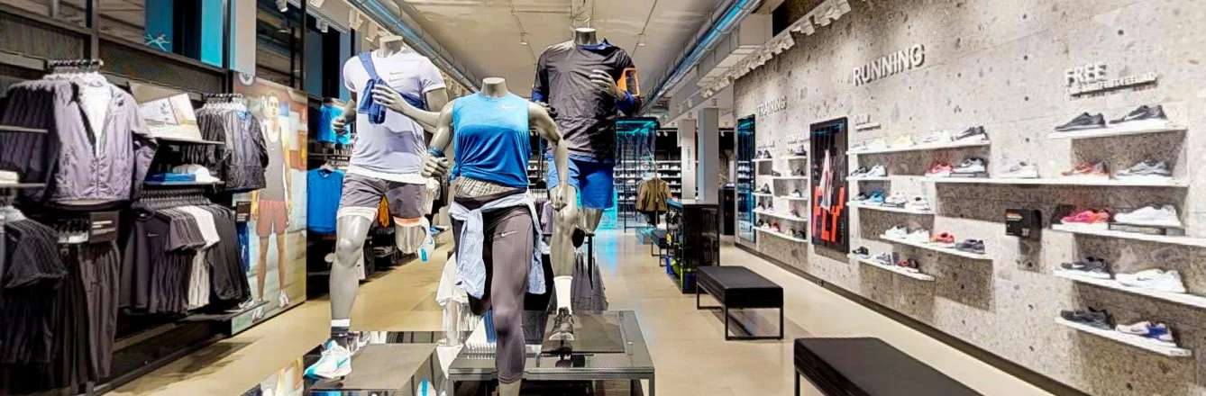
Professional Real Estate
Virtual tours, photography, floor plans and rich media that let remote and local buyers understand a property before they ever request a showing.
Brokers and agents use these scans as a quiet sales funnel, pre qualifying interest, guiding serious buyers through every room, and feeding more actionable data into their CRM and marketing platforms. The result is a more modern portfolio, higher confidence leads, fewer low value showings, and more time spent writing offers and closing profitable deals. -
Art Galleries And Event Spaces
3D tours, photography, and layouts that show how exhibitions and events really live in the room, then keep working after the doors close.
Galleries, museums, and venues use these assets to attract visitors, support rentals, and turn each scan into a quiet sales funnel by linking works, tickets, memberships, and booking inquiries directly inside the tour. Temporary projects keep generating interest and revenue long after the closing reception. -
Vacation Rentals
3D tours and honest visuals that let guests understand layout, beds, and amenities before they book.
Short term rental hosts and STR operators use these scans and media across Airbnb, Vrbo, and direct sites to reach more qualified guests, cut down on repetitive questions, and reduce mismatched expectations. The result is a smoother booking funnel, better reviews, and more revenue per property with less time spent hand holding every inquiry. -
Interior Designers And Space Planners
3D capture, photos, and layout views that show how furniture, finishes, and lighting actually work together in real rooms.
Designers use these assets to review spaces with clients remotely, collect feedback from multiple stakeholders, and document finished work in a way that supports future proposals and referrals. The visuals drop easily into mood boards, presentations, and project platforms, which streamlines approvals, strengthens credibility, and helps each completed project generate the next one. -
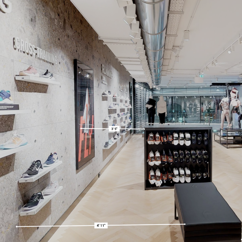
Retail And Local Spaces
3D tours, Google Street View content, and strong photography that help people feel your shop, studio, or gallery before they visit.
Owners use these assets on their website and Google Business Profile to improve discovery, attract more qualified foot traffic, and guide visitors toward key products or services. The same visuals feed your social, email, and ad campaigns, which streamlines marketing, strengthens credibility, and supports higher revenue per visit -
Insurance And Restoration
3D loss capture, photos, and measurements that create a clear record of conditions at a specific point in time.
Carriers, adjusters, and restoration contractors use these assets to support scopes and Xactimate estimates, answer file review questions, and limit repeat site visits. The same visuals feed reports, claim systems, and documentation packages, which improves communication, reduces friction between parties, and protects profitability on both the claims and construction side. -
Telecom And Infrastructure
Site and facility documentation that shows towers, compounds, shelters, and critical rooms in real context.
RF, AEC, construction, and operations teams use this record to compare candidates, plan upgrades, and coordinate work without sending every stakeholder to the field. Deliverables are easy to share in a browser and can support existing engineering and project tools, which helps reduce truck rolls, prevent surprises during build, and keep network projects on schedule and on budget.
What We Do
Property Masters 3D turns real spaces into clear, shareable visuals that reduce guesswork, cut extra site visits, and help your projects and portfolios perform better.
Why Teams Trust Property Masters 3D
Every tour and photo set is backed by a production operation built for real projects and real accountability for government buyers, disciplined facilities teams, and mission partners who plan years ahead.
Property Masters 3D is a South Florida based small business formed in 2021 and built to support both commercial and public sector work. We combine field experience, structured deliverables, and the registrations agencies expect, so your team can bring us into conversations with owners, primes, and stakeholders with confidence.
SAM.gov registered small business with active CAGE code
State of Florida MFMP registered vendor
Registered vendor with Miami-Dade County
State of Florida Certified Minority Business Enterprise
FEMA ICS / NIMS training (IS-100, IS-200, IS-700, IS-800)
FAA Part 107 licensed drone operations
Experience supporting municipalities and private clients under FEMA guidelines.
OSHA HAZWOPER training (40 Hour, 8 Hour Supervisor)
How A Property Masters 3D Project Works
From first conversation to ready-to-use assets in your team’s hands.
-

Step 1 · Share The Property And The Goal
Tell us about the space, the address, approximate size, and what you are trying to accomplish.
Renovation, marketing, insurance, or portfolio planning all have different needs.
We review any drawings or photos you already have and come back with a clear scope, recommended deliverables, and a straightforward quote. -
Step 2 · Capture The Space In 3D
We schedule on-site scanning with Matterport and supporting photo or drone work, timed around your operations so there is minimal disruption.
Our team documents the property once and turns it into accurate 3D data that can feed tours, floor plans, CAD or BIM-ready files, and high-impact visuals. -
Step 3 · Deliver Files And Activate Your Team
You receive secure links and files in the formats your team actually uses, including 3D virtual tours, floor plans, point clouds, image sets, and project-specific exports.
We walk key stakeholders through the deliverables so they know how to use them for design, listings, STR marketing, insurance workflows, or asset management.
The result is fewer site visits, faster decisions, and more revenue from better informed projects.
Property Masters 3D: FAQs
-
A 3D virtual tour is the shareable walkthrough experience—great for marketing, leasing, and remote viewing. A digital twin goes a step further by serving as a measurable visual record that supports documentation, planning, coordination, and repeatable stakeholder review over time.
-
We support residential, commercial, retail, hospitality, industrial, and facilities environments—plus specialized use cases like construction progress, insurance documentation, and public-sector sites. If access is possible, we can usually capture it.
-
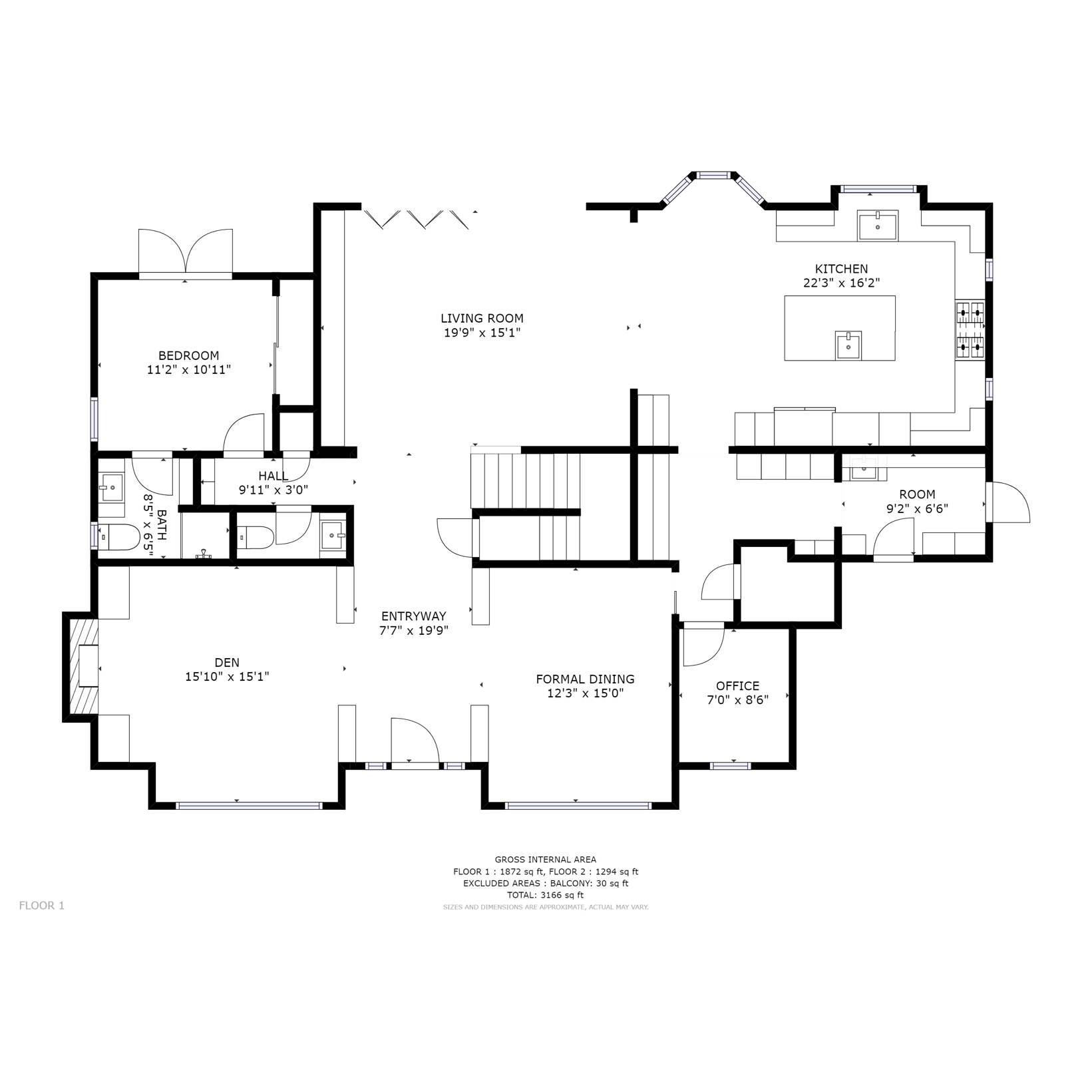
Most projects include on-site capture, a branded shareable link, dollhouse and floor plan views, basic model cleanup (navigation polish, trimming, alignment), and a simple delivery package with sharing notes and files/links organized for stakeholders.
-
Yes. We can provide schematic floor plans and other measured/structured outputs depending on the service and scope. We’ll confirm what you need (and what level of accuracy is required) during quoting.
-
Yes. We support AEC-friendly documentation and can deliver exports and files aligned to the scope (example outputs may include point cloud–based workflows and CAD/BIM deliverables). To quote accurately, we confirm deliverables, LOD, coverage, and access first.
-
Depending on scope, we can deliver outputs such as schematic floor plan (PDF/SVG/PNG) and AEC documentation exports like E57 point cloud, MatterPak (OBJ/XYZ), and BIM/CAD formats (RVT/DWG) where applicable. Final formats are confirmed during scoping so they plug into your workflow cleanly.
-
Most marketing deliverables land 24–72 hours after capture (many projects land within 48 hours). Larger properties, multi-site work, and technical documentation can require additional time based on scope, review cycles, and access constraints.
-
To quote cleanly, we typically confirm: address/location, approximate size, property type, access notes, desired deliverables, timeline/turnaround, and any special constraints (occupied space, restricted areas, after-hours access, safety requirements, etc.).
-
Yes. We serve Miami-Dade, Broward, and the surrounding South Florida region, and we can support travel for the right scope. Travel, access conditions, and scheduling windows are confirmed during quoting.
-
Yes. Your deliverable is designed to be easy to share across email, web, listings, QR codes, and internal teams. If you need branded entry screens, CTA placements, or link strategy, those can be included as upgrades.
-
Yes. Google Street View publishing is available as an add-on when appropriate for the space and location. We’ll confirm eligibility and preferred publishing approach during scoping.
-
Yes. We can add Mattertags, room labels, instructions, and CTAs to support leasing, self-guided tours, training, facilities notes, or visitor guidance—depending on how you intend to use the digital twin.
-
Both options work. You can host on your own Matterport account, or we can professionally host and manage the space as an add-on. If hosting is handled by our team, we’ll confirm retention period, access roles, and handoff options.
-
Yes. We offer portfolio and multi-site workflows, including standardized naming conventions, repeatable deliverables, and stakeholder-ready reporting. Volume pricing and cadence-based programs are available by quote.
-
We don’t just capture visuals—we deliver operationally useful documentation. Our approach is built around clean scope, consistent output standards, and stakeholder-ready delivery, so your team can make decisions faster with fewer site visits and less rework.
-
Choose the service that matches your goal, then request a quote. We’ll confirm scope, access, deliverables, and turnaround—then schedule capture and deliver a clean package your team can immediately use.
Step Inside A Sample Project
When a space is documented the right way, a single capture can support leasing, design, operations, and ownership at the same time. These examples shows how one 3D record turned into real value for multiple teams.
Sample Project: Full Floor Office Shell With Skyline Views
A full-floor “vanilla shell” office in a high-rise needed more than static photos to sell its potential. Brokers and tenants had to understand both the raw structure and what a finished space could feel like.
Property Masters 3D first captured the entire floor in 3D, documenting the exposed concrete structure, core elements, and continuous window wall with panoramic skyline views. From that same model, we produced a virtually staged version that showed a complete fit-out: furniture, finishes, and layout options that matched a modern workplace.
Leasing teams, prospective tenants, and interior designers used the side-by-side views—shell and virtually staged—to review circulation, daylight, and planning zones from anywhere, without repeated site visits. The capture supported early test fits, marketing campaigns, and owner-level decisions about how to position the asset in the market.
Single 3D capture used for both “as-is” documentation and fully staged visualization
Clear view of structure, natural light, and planning options without extra field trips
Virtual staging that turns a bare shell into a compelling workplace story for tenants, investors, and design teams
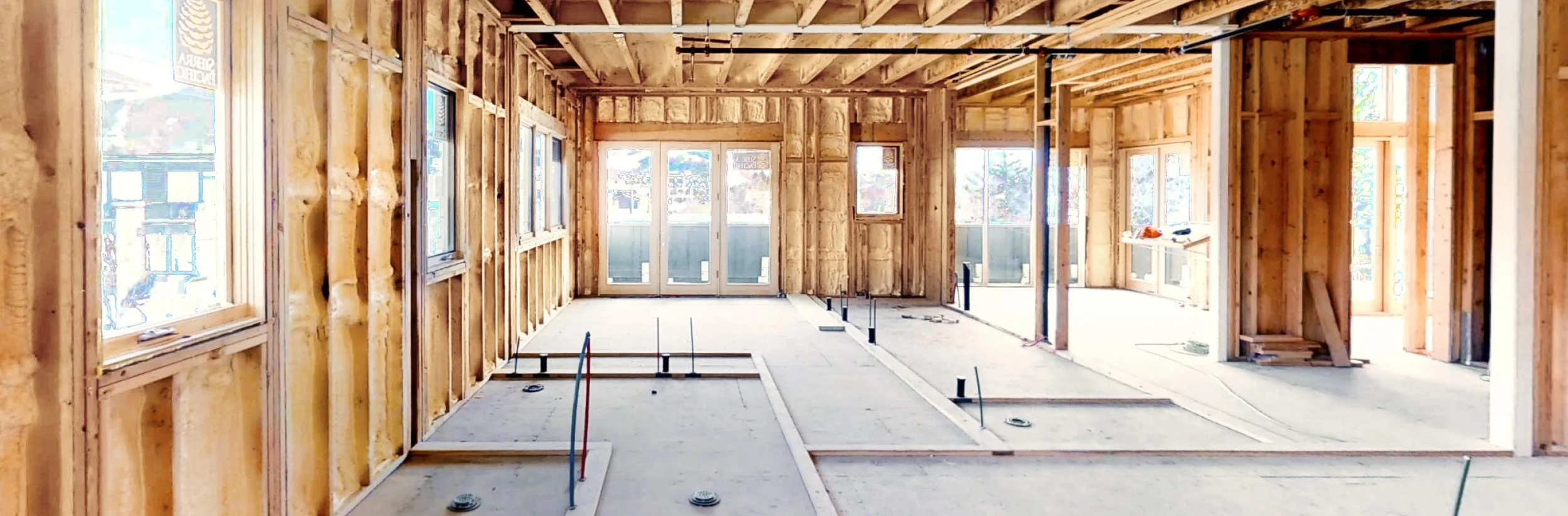
Sample Project: Miami Beach Multistory Residence
This three-story luxury residence in Miami Beach was captured during the rough-in stage, with framing, mechanical, electrical, and plumbing fully exposed. Split-level interiors, large window walls, and multiple terraces overlooking the neighborhood and waterway make it a high-value project with a lot of complexity hidden behind the future finishes.
Property Masters 3D documented the entire structure with a Matterport Pro2 walkthrough, high-resolution pano stills, and a detailed dollhouse view. The model gives architects, builders, and owners a single navigable record of every stud, conduit, and pipe run before drywall, so teams can coordinate trades, resolve clashes, support change orders, and verify work for lenders and insurers without repeat site visits.
Full multistory capture at rough-in for complete MEP and framing visibility
Split-level, terrace-heavy layout ideal for coordination and design review
Single 3D model used by GC, subs, architect, and owner for decision-making
Supports RFIs, change orders, and draw requests with clear visual evidence
Reduces return site visits while protecting everyone’s understanding of “what’s in the walls”
Ready To Talk About Your Next Space Or Site
If you share a little about your property, your role, and what you are trying to solve, we can recommend a mix of services that fits.
Whether you are planning a renovation, marketing a portfolio, documenting a loss event, or supporting a government or telecom project, the goal is the same. Give your team a clear, honest view of the space so decisions are faster, visits are more targeted, and each project has a stronger chance of paying off.
Trusted, Registered, and Ready for Serious Work
Property Masters 3D is already in the systems your team relies on, which means less onboarding, faster approvals, and a smoother path from first call to project kickoff.


SAM.GOV REGISTERED · CAGE 9EFJ2
〰️
STATE OF FLORIDA · MFMP VENDOR
〰️
MIAMI-DADE COUNTY · REGISTERED VENDOR
〰️
FAA PART 107 · REMOTE PILOT
〰️
SAM.GOV REGISTERED · CAGE 9EFJ2 〰️ STATE OF FLORIDA · MFMP VENDOR 〰️ MIAMI-DADE COUNTY · REGISTERED VENDOR 〰️ FAA PART 107 · REMOTE PILOT 〰️